Frans J.P.M. Kwaad,
physical
geographer
See also:
Soil
conservation in Europe
Ephemeral
Gully Erosion
Economic
costs of soil erosion
In this site, 12 slideshows of features of soil erosion are presented. See further down.
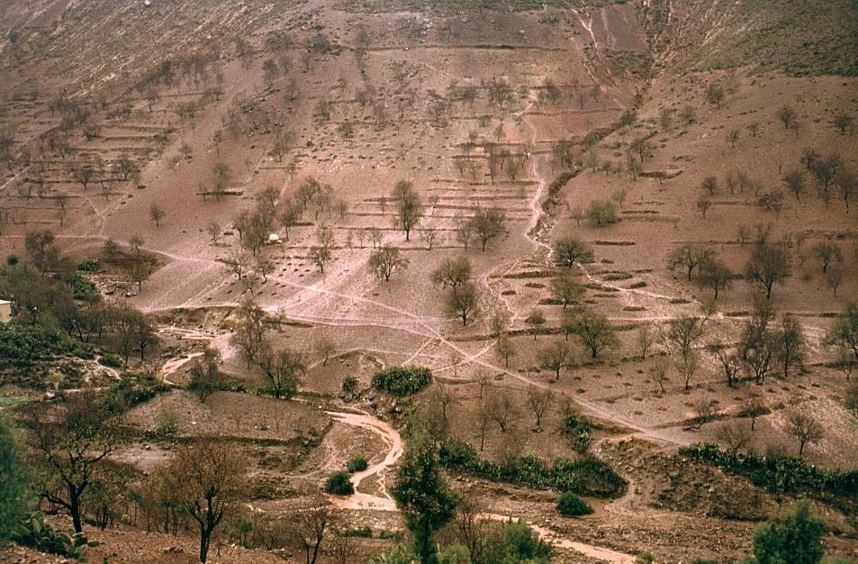
A soil erosion event near Beni Boufrah, Rif Mountains, Morocco
Introduction
Soil erosion research started in the 1920's in the USA (Gilley
and
Flanagan,
2007). Despite 90
years of research, soil erosion still continues to be a serious
problem, worldwide. According to Napier (ESSC Newsletter, 2012/1, pp.
3-10) the explanation of this lies in the fact that soil
erosion control is not mainly, or not anymore, a scientific problem or
a
technical problem or a matter of education or information of the
farmers, at least in the USA. Farmers know what to do to combat erosion
on
their fields. The problem is how to induce farmers to implement or to
maintain conservation measures on their farm, in a time of economic
crisis with reduced public conservation funding, the upcoming of
grain-based energy, increased grain prices and an expected mass exodus
from land set-aside programs. No longer can be relied on voluntary
participation in conservation programs, the cornerstone of US
conservation policy for decades, because most conservation production
systems are seldom profitable in the short-term and, often, not even in
the long term. Some form of coercion will be required to achieve
participation, according to Napier (2012) in his analysis of the
conservation situation in the USA. For Europe, see the final
report of the SoCo-project: Addressing
soil
degradation
in
EU
agriculture and Soil
conservation in Europe. For a world view of erosion see Glasod.
The article by Napier (2012) can be read online in Newsletter 1/2012 of the ESSC on the website of the ESSC (European Society for Soil Conservation).
There is discussion regarding the magnitude of the erosion problem. Pimentel (2006 and older
publications) claims the yearly damage of erosion to be 400 billion US
dollars
worldwide. Crosson
(1995) disagrees with this. See also Boardman
(2006)
Soil
erosion science: Reflections on the limitations of
current approaches. This paper is a must-read for everyone engaged
in soil erosion research!
The issues of the extent and scale and persistence of the erosion
problem are not discussed any further in this site. It is the purpose
of this site to provide examples of the various aspects of soil
erosion, mainly for educational use.
Eroded
land
in
Morocco,
Rif
Mountains,
west
of
Al
Hoceima
Do erosion and topsoil formation than take place simultaneously? Yes. Erosion is the removal of soil material at the soil surface by the process of rain wash. Soil formation is the downward growth and extension of the soil profile, and its various horizons, by percolating rain water and through biologic activity. Under natural conditions (e.g. forest) on sloping land, there is a balance between the process of soil formation on the one hand and surface removal of soil material on the other hand. When and where this is the case, we speak of geologic or normal erosion. The soil profile is the long term expression of this balance. This balance can and will be disturbed, when sloping land is used for agricultural purposes. The rate of soil loss by erosion increases ten to hundred-fold under agriculture, without a concomitant and comparable, compensating increase of the rate of soil formation. This is called accelerated erosion above the geologic norm, or soil erosion s.s. It leads to the rapid loss of the soil's superficial horizons, called truncation of the soil profile. Ultimately, the soil can be washed away altogether, down to the underlying bed-rock. In this way, soil that was formed over a period of hundreds or thousands of years, can be lost within years. Besides, linear erosion features (rills and gullies) can develop in the soil and its underlying substrate, if this is composed of unconsolidated material. The productivity of land and soil decreases, when this happens. This is an irreversible process, that cannot be made good with fertilizers. Once the soil is gone, it is gone for many generations to come.
The counterpart of soil erosion in certain parts of the landscape, is increased deposition or sedimentation in other parts of the landscape. Even river regimes can be altered, due to upsetting of the water balance by soil erosion, giving rise to problems of flooding and siltation. These so called off-site effects of soil erosion can be just as deleterious as the on-site effects.
Soil conservation is the protection of the soil against soil erosion. It comprises the whole range of measures that can be taken to prevent or reduce soil loss by soil erosion. The goal of soil conservation is to maintain sustained productivity of the soil and to combat the off-site effects of soil loss.
Soil erosion by rainwater occurs, when more rain falls than can be absorbed by the soil. When this is the case, part or all of the rainwater flows downslope across the soil surface. This is termed overland flow. The overland flow carries soil particles that are detached by the flow and/or by the impact of falling raindrops (splash erosion). Concentration of overland flow can give rise to rill erosion and ultimately to gully erosion.
Two different sets of conditions can give rise to overland flow:
(a) During high intensity rainfall, more rain may fall per time unit
than can enter the soil through the soil surface. Only part of the rain
infiltrates into the soil. The excess rainfall moves downslope as
overland
flow. The soil may be dry, when this happens. In technical terms: the
infiltration
capacity (i.e. maximum rate of infiltration) of the soil is exceeded by
the rainfall rate or intensity, both expressed in mm/hour.
The rate of infiltration is controlled by the state of the soil
surface. The soil surface is susceptible to changes. Breakdown of the
soil structure can occur due to raindrop impact if the soil is bare.
This can lead to slaking and crusting at the soil surface and a reduced
rate of infiltration of rain water.
(b) The infiltration of rainwater in the soil is completely checked,
when a (perched) groundwater table is present at, or rises to, the soil
surface during rainfall. The storage capacity of the soil for water
above
an impeding layer is the controlling variable in this situation,
expressed
in mm of rain.
Click on a
title in blue to start a slideshow.
When you are on a slideshow,
click on the icon in the left-hand top
corner for a full-screen view of the images.
2. Degradation of
soil structure, surface sealing and crusting (24
images)
Breakdown of soil structure sets the stage for soil
erosion by running water. Through
welding, slaking and dispersion of structural elements of the soil
(clods, crumbs), sealing and crusting of the soil surface can take
place. The maximum rate of infiltration of rainwater is lowered by
this, leading to overland
flow and erosion. Photo's are taken in the
Netherlands (Zuid-Limburg, Meinweg), Luxembourg and Morocco. On the
first two slides an overview of 8 slaking classes (Dutch:
verslempingsklassen) is given, as
compiled by Boekel. This photosheet can be used in the field as a
reference when describing the actual state of slaking, by comparison
with the 8 photo's. The term slaking refers to the loss of soil
structure that can be observed in the field with the naked eye. More
technically, slaking is defined as the disintegration of
structural elements of the soil into micro-aggregates and skeleton
grains (sand grains). This leads to
clogging of soil pores and to a lowering of the infiltration capacity
of the soil for rainwater. There is discussion on the exact causes and
mechanism of slaking and other forms of structural breakdown. See Imeson-Kwaad,
1990 and Kwaad-Mucher,
1994 for more information.
4. Sheet
erosion, interrill erosion (11 images)
The concept of sheet erosion is not as clear as it may seem at first
sight.
Originally, sheet erosion or sheet wash was described by Bennett (1939,
p. 96) as: "Sheet washing is the
more or less even removal of soil in thin layers over an entire
segment of sloping land." He adds: "Sheet erosion grades so imperceptibly
into rill erosion that the two cannot everywhere be sharply
differentiated." Concerning rill erosion he writes: "Instead of flowing evenly over a sloping
field, runoff water generally tends to concentrate in streamlets of
sufficient volume and velocity to generate increased cutting power."
This implies that sheet erosion was seen as being caused by a film or
sheet of water flowing over the land. Later, it appeared that such
'sheet flow' is rare (Schwab et al., 1966, p. 164). More often than
this, the water is not deep
enough to flood the higher parts of the uneven soil surface (the
so-called
soil microtopography or surface roughness). The water only fills and
follows the depressions of soil microtopography. This is termed 'rill
flow' (or maybe better 'pre-rill flow'), with 'interrill flow'
occurring on the areas between the rill flowpaths. Not all rill
flowpaths become real erosion rills. It cannot be said beforehand which
ones will. We don't even know for sure if erosion rills (always)
develop from the rill flowpaths governed by soil microtopography
(Favis-Mortlock,
1998; Darboux
et
al.,
2001). On the interrill areas, interrill erosion takes
place. This is mainly
splash erosion. In the Glossary of Soil Science Terms (1978)
it is said that sheet erosion often is interpreted to include rill and
interrill erosion. So, today, sheet erosion is seen as the combined
effect of rill and interrill erosion. No 'more or less even removal of
a thin layer of soil' takes place during rainfall. It is by
tillage after rainfall that the soil loss, that is due to rill and
interrill erosion,
is more or less evenly smeared out over the eroded field, resulting in
an almost imperceptible (but very real) lowering of the soil surface.
Bennett (1939) speaks of sheet erosion as "the least conspicuous and the most
insidious type of erosion". By some authors sheet erosion is
equated with interrill erosion. Photo's were taken in Morocco (Rif
Mountains) and The Netherlands (Zuid-Limburg).
5. Rill erosion
(43 images)
Rill erosion is the formation of rills that can be removed by normal
tillage. They are short-lived features. Mostly, they are formed during
a single rain storm. Two types of rills are shown in the slides: (1)
series
of closely spaced parallel rills on slopes, and (2) single rills in
wide and shallow topographic
depressions. Maybe the latter ought to be termed ephemeral gullies or
proto-gullies.
Photo's were
taken in Luxembourg (Gutland), The Netherlands (Zuid-Limburg) and
Morocco.
6. Gully
erosion (26 images)
Guly erosion is the formation of gullies that are too deep to be
removed by normal tillage. Gullies are formed in unconsolidated soil
material, with the deeper parts sometimes penetrating in
underlying soft rock types such as (partly weathered) chalk or marl
(e.g. slides nrs. 10 and 13). Several types of gullies can be
distinguished, a.o. valley
side gullies, valley bottom gullies, V-shaped gullies, U-shaped
gullies, continuous gullies, discontinuous gullies, arroyo's, badlands.
Photo's
were taken in Morocco, Rif Mountains, 40 km west of Al Hoceima.
7. Ephemeral
gully erosion (26 images)
Ephemeral gullies are shallow gullies that are very much wider than
deep. They can
be removed by normal tillage. They tend not to go deeper than the
plough layer. Photo's were taken in The Netherlands (Zuid-Limburg),
aerial photographs taken by D. Koeman. The
slides nrs. 07 to 14 are of an event of 55 mm of rain in 2 hours incl.
30 mm in 30 minutes. For a more detailed discussion of ephemeral
gullies see: Jeroen
Nachtergaele.
8. Piping
(9 images)
Piping is the formation of pipes or tunnels by subsoil erosion. Piping
occurs under specific conditions, such as a salt containing soil (the
white material on some of the images). Photo's were taken in Morocco,
Rif Mountains, 40 km west of Al Hoceima.
9. Deposition
of colluvium (24 images)
Eroded soil is deposited as colluvium on lower parts of the slope or at
the foot of slope, and also as sediment in rivers, lakes and
reservoirs. This is a so-called off-site effect of erosion. Photo's
were taken in Luxembourg and The Netherlands (Zuid-Limburg).
11. Damage to
crops, roads and built-up areas (29 images)
By soil erosion, damage to crops (uprooting, or burial with colluvium)
can occur, or damage to roads (removal of pavement, deposition of mud)
and to residential areas (flooding, mud deposition, undermining of
houses). Photo's were taken in The Netherlands (Zuid-Limburg) and
Morocco, Rif Mountains near Bni Boufrah. These
are forms of short-term damage by soil erosion. The long-term damage
lies in the irreversible loss of fertile topsoil, as caused by the
various forms of erosion mentioned under nrs. 3 tot 8.
Click to view this
slideshow on tablet: Damage
by erosion
Besides erosion by running water, there are other processes that can
cause downslope movement of soil material on sloping land. An important
group of processes is so-called mass wasting (soil creep, frost creep,
solifluction, mudflow, slumping, landslide, rockfall). Another process
is the net downslope displacement of soil material on sloping arable
land as a direct effect of soil tillage. This is called 'tillage
erosion'. In fact, it shows more resemblance to soil creep than to
soil erosion. It has been studied in great detail by Govers (2006).
Tillage erosion can contribute to the formation of 'lynchets'.
12. Lynchets (10 images)
Lynchets are terrace-like steps on slopes, aligned
parallel to the contours. They were not constructed intentionlly but
gradually have taken form on agricultural land at field boundaries that
are grown or planted with hedgerows. Loss of soil
material at the downslope side and accumulation at the upslope side is
involved in the formation and development of lynchets. This can be due
to erosion and/or tillage. Some are very
old, semi-permanent
features of
cultural landscapes in Europe, (partly) inherited from the past,
representing former land use practices and patterns. Many have been
bulldozered
away, e.g. in Dutch South-Limbourg. They are
named 'graften' in Dutch, 'rideaux' in French,
'Stufenraine' in German. Photo's were taken
in The Netherlands
(Zuid-Limburg) and
Morocco.
Soil erosion songs
(21
songs)
Soil, floods and erosion have inspired people to write songs with
titles such as "A love song for soil" and "Don't treat it like dirt".
Listen, sing along and enjoy!
References
- Bennett, H.H., 1939. Soil
Conservation. McGraw-Hill Book Company, New York, 993 pp.
- Boardman, John, 2006. Soil
erosion science: Reflections on the limitations of
current approaches. Catena 68, pp.
73-86. Text
online.
- Crosson, Pierre, 1995. Soil
erosion estimates and costs, with Response by Pimentel et al. Science,
Vol. 269, 28 July 1995, pp. 461-465. Text
online.
- Darboux, F., Davy, Ph.,
Gascuel-Odoux, C. and Huang, C., 2001. Evolution of soil
surface rougness and flowpath connectivity in overland flow experiments. Catena 46, pp. 125-139. Text
online
- Favis-Mortlock, D., Boardman, J.,
Parsons, T. and Lacelles, B., 1998. Emergence and erosion: a
model for rill initiation and development. From
Abrahart,
R.J.
(ed.)
(1998).
Proceedings
of
the
Third
International
Conference
on
GeoComputation
(CD),
University
of
Bristol,
17-19
September
1998. Text online
- Gilley, J.E. and Flanagan, D.C. 2007. Early investment in
soil conservation research continues to provide dividends. Transactions American Soc. Agric. Biol.
Engineers, Vol. 50 (5), pp. 1595-1601. Text
online
- Imeson, A.C. and Kwaad, F.J.P.M., 1990. The response of tilled
soils to wetting by rainfall and the dynamic character of soil
erodibility. In: Boardman, J.,
Foster, I.D.L. and Dearing, J.A. (editors), Soil erosion on
agricultural land. Wiley, Chichester, pp. 3-14. Text online
- Kwaad,
F.J.P.M.
and
Mücher,
H.J.,
1994. Degradation of soil structure by
welding - a micromorphological study. Catena, 23, pp.
253-268. Text
online
- Kwaad,
F.J.P.M., Van der
Zijp,
M. and Van Dijk, P.M., 1998. Soil conservation and maize
cropping
systems
on sloping loess soils in The Netherlands. Soil and Tillage Research,
Vol.
46, pp. 13-21. Text
online
- Lindstrom, Michael J., 2002.
Tillage
erosion,
description
and
process
of.
USDA.
Text
online.
- Napier, Ted L., 2012. US
conservation achievements threatened by future prosperity of the
agricultural sector. Guest
Editorial, ESSC Newsletter, 1/2012, pp.
3-10. Text
online.
- Pimentel, David, 2006. Soil
erosion: a food and environmental threat. Environment, Development and
Sustainability, 8, pp. 119-137. Text
online
- Schwab, G.O., Frevert, R.K.,
Edminster, T.W. and Barnes, K.K., 1966. Soil and Water
Conservation Engineering. Second Edition. John Wiley and Sons, New
York, 683 pp.
- Soil Net for education on soils
- Soil Science Society of America, 1978.
Glossary
of
Soil
Science
Terms,
36
pp.
- Van Oost, K., Govers, G., De Alba,
S. and Quine, T.A., 2006. Tillage erosion: a review of
controlling factors and implications for soil quality. Progress in
Physical Geography, 30, pp.
443-466.
===========================================================================================================
Viewing the slide-shows on tablet or
smartphone
For the slide-shows on this website, Adobe Flash Player is used.
Flash is not supported by iOS and Android. Therefore, it is not
possible to view the slide-shows on tablet or smartphone. However,
there are apps to overcome this obstacle. See for instance these lines
taken from a review
of
Flash
vs.
HTML5 :
2. Mobile devices do support HTML5, but also Flash -
through the appstore.
Android devices support Flash in
the mobile browser up to Android v 4.0, but iPads and iPhones do not.
The future of Flash on mobile devices and tablets is not in the
web-browser though but in the appstore. These are Flash apps
specifically designed for touch-screen interfaces. iPads and iPhones do
support Flash-based apps through the appstore, and Android devices
through the Google Play Store. Many of the most popular iPad and
Android apps are Flash-based (you just don't know it, because it is not
advertised anywhere).
Hopefully, visitors of the site can find their own way in this new
development of mobile access to images and sounds. The author has tried
to put up three of the slide shows (nrs. 1, 10 and 11) in a non-Flash
coding, by way of experiment. The coding used is not ideal, however,
because of problems with portrait vs. landscape pictures. Please, let
me know, if you know of a better solution.